
A non-profit based in Charlotte, North Carolina, RAO Community Health is working with support from CDC’s REACH program to find innovative ways to use data to make better decisions about our built environment to create healthier, more prosperous places for people to live and thrive.
Mapping access to destinations for the most vulnerable people
To support their work in Charlotte, the team at RAO Community Health (RAO) has been looking into where the most vulnerable residents are living, with an eye toward more effectively targeting resources where they can make the biggest impact. RAO has been collaborating with the University of North Carolina at Charlotte (UNCC) to develop a methodology for the spatial assessment (i.e, maps) of current conditions related to health disparities and nutrition in the counties surrounding Charlotte. RAO and UNCC worked to develop these “social vulnerability maps” with an overarching goal of identifying the number of SNAP-approved stores (SNAP, formerly known as food stamps) related to various points of interest, including income level, education, rate of homeownership, and transportation access.
One of the key findings is that a high number of SNAP users in the region had little to no transportation access, which is a measure of the ease of reaching (and interacting with) destinations or activities in a particular space (in this case, Charlotte), whether it be by walking, rolling, biking, moving actively with an assistive device, or using transit. “High accessibility” means many destinations can be reached, and destinations can be reached with relative ease.
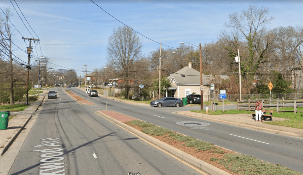
The next step was developing walkability maps to better understand the areas where transportation access was most limited. Of those areas, Parkwood Avenue was one of the most difficult places for people to reach SNAP-approved stores, due to low accessibility caused by two lanes of traffic in either direction, narrow sidewalks, no bike lanes, and few signalized crossing opportunities.
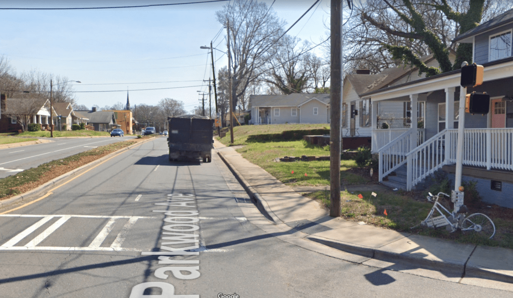
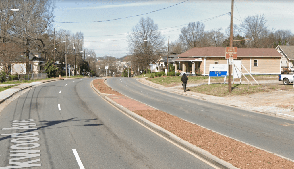
Parkwood Avenue is a poster child for the kind of auto-oriented design that actively divides the neighborhood, separating people from essential services and resources that appear to be so close on the map. In that neighborhood, “just across the street” is neither safe, nor welcoming, for people walking, rolling, moving actively, or using assistive devices.
Parkwood Avenue is also one of many inner city neighborhoods in Charlotte that is being rapidly gentrified, with a high risk of its currently underserved residents being further displaced from already difficult to reach essential services and resources. It’s a neighborhood where access to daily needs is already difficult, yet residents run the risk of being pushed out and into other areas that are even more auto-dependent or that have even lower densities of their daily needs nearby.
The impacts of walkability on people’s quality of life and RAO’s growing understanding of this issue led them to partner with another local non-profit with specialized experience, Sustain Charlotte, that advocates for sustainable land-use and transportation decisions. Together, they have been working to address some of the challenges that residents face by advocating for improvements to the streets, focusing on connectivity, and getting people where they need to go.
As they examined the impact of walkability and connectivity, RAO and Sustain Charlotte used the newest tool developed by Smart Growth America, in partnership with CDC’s Active People, Healthy Nationsm Initiative, Measuring the Benefits of Complete Streets. By applying this tool to predict the impacts of a specific in-progress Complete Streets project on Parkwood Avenue, RAO and Sustain Charlotte could discover and quantify numerous benefits that a simple change in road design could have on residents.
Predicting the impacts of a redesigned Parkwood Avenue
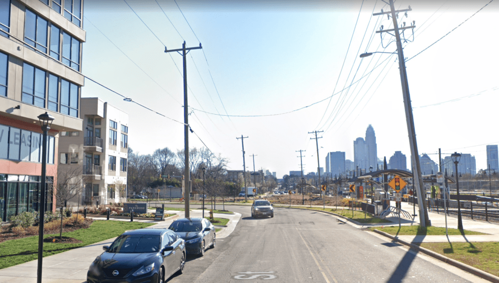
Parkwood Avenue is a minor arterial in northeast Charlotte that traverses the neighborhoods of Belmont, Optimist Park, and Villa Heights. As population growth has boomed in Charlotte, so have traffic volumes on this winding and hilly street. With two lanes of traffic in either direction, narrow sidewalks, no bike lanes, and few signalized crossing opportunities, Parkwood is a daunting street for people outside motorized vehicles. At the same time, it’s also an attractive area that is close to vibrant small businesses, multimodal transportation connections, and Uptown. Key connections adjacent to Parkwood Ave include the Blue Line Extension light rail with nearby Parkwood Station and new connections to the Cross Charlotte Trail (a forthcoming bike/ped trail that will connect the county from north to south).
Recognizing the challenges and the potential of the corridor, a road diet project is already underway on Parkwood Avenue, led by the City of Charlotte. But even with that important project in progress, RAO and Sustain Charlotte were able to use this Measuring the Benefits of Complete Streets Tool to go ahead and predict the impacts that the new street design would have on residents in the area, including measures that would affect people’s safety, health, the environment, and the local economy.
Key benefits expected:
Fatalities reduced by 75 percent
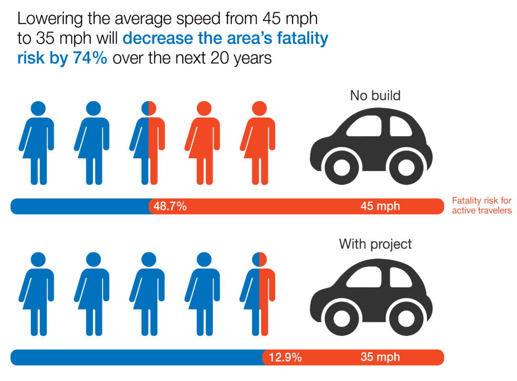
As a result of intense advocacy by Sustain Charlotte and neighborhood residents, the City of Charlotte adopted a Vision Zero goal in 2017 to eliminate traffic fatalities and serious injuries on city streets by the year 2030 as an objective in its Transportation Action Plan. Sustain Charlotte has served on the Vision Zero Task Force since its inception in 2018 and is eager to use the Complete Streets Tool as a quantitative strategy to make the case for increased investment in, and continuing commitment to, Vision Zero infrastructure, policy, and education. Charlotte DOT staff regularly hear from vehicle drivers who want to see traffic speeds increased on city streets. The Complete Streets tool allows us to predict how many more lives are likely to be lost as a result of higher effective speeds, which can build political will to lower traffic speeds or increase cycle length for pedestrian crossings.
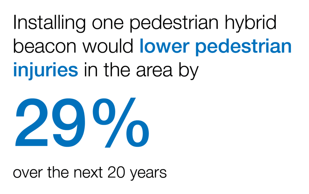
Specifically, the tool allows us to test the likely impact of various intersections treatments including pedestrian hybrid beacons, high-visibility or raised crosswalks, and advanced yield or stop markings and signs. In these modern days when “time is money”, the tool gives us objective evidence-based rationale to advocate for traffic calming instead of prioritizing free-flow of traffic above all else. In this case, the road diet on Parkwood Avenue will reduce fatalities 75 percent. When the output of the model is human lives saved, policymakers are likely to pay attention!
Supporting the city’s mode share shift goal
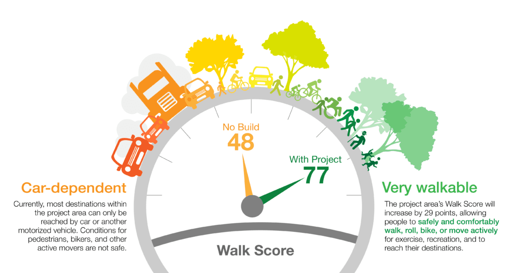
The City of Charlotte is working to create a Strategic Mobility Plan to address mobility and transportation needs for the Charlotte area over the coming decades. With high levels of continued population growth projected in the booming city and region, there will be serious issues without finding a way to reduce the current percentage of residents (76 percent) who commute to work by driving alone. The Complete Streets tool predicts how many new cyclists and daily cycling trips will be supported within the project area over the next 20 years. It allows us to test a ‘Build’ vs. ‘No Build’ scenario. Because there is often a lag in time between when infrastructure is added and when mode share shift occurs, folks have historically struggled with finding ways to quantify the mode share impact of investing in bike lanes, sidewalks, crosswalks, and other complete streets infrastructure. This tool provides the ability to explain how investments made today are likely to impact mode share in 10 or 20 years.
Demonstrating how certain investments are better than others at meeting city climate goals and county air quality goals
Mecklenburg County, in which the City of Charlotte is located, is a maintenance area for the primary air pollutant of concern, ground-level ozone. We are just barely meeting federal standards and this is a real challenge as our growing population means more cars on the road.. The City of Charlotte adopted a Strategic Energy Action Plan (SEAP) to become a low-carbon city by 2050 by reducing annual greenhouse gas emissions to below 2 tons of CO2 equivalent per person. The Cycling Environment module of the tool provides a quantified prediction of reductions in greenhouse gas emissions and other air pollutants that are known to be harmful to human health, or are precursors to ground-level ozone. We are eager to use this tool across the city to advocate for active transportation and land use projects that will reduce impacts on both climate change and local air quality.
Demonstrating how Complete Streets projects can help meet city-adopted goals for health
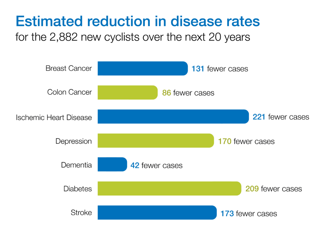
The Charlotte Future 2040 Comprehensive Plan (scheduled for City Council adoption on June 21, 2021) includes a goal to support “Healthy, Safe, and Active Communities” and envisions a city in which “All Charlotteans will live and work in safe and resilient neighborhoods that enable healthy and active lifestyles.” The Cycling and Pedestrian Health Module of the tool gives us the ability to predict reductions in rates of common diseases (related to enhanced opportunities for daily physical activity) over 20 years for the people who switch to more biking.
Supporting equitable development goals that prevent displacement
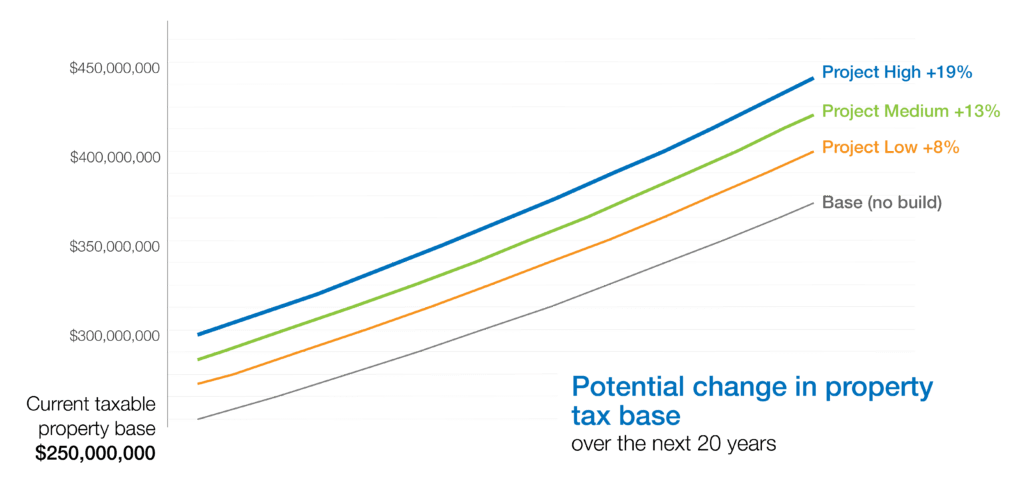
Improvements to the Parkwood Avenue corridor will make the area a safer, healthier, more accessible place to live for the people who live there today. Left unchecked, the positive benefits from the road diet project could increase property values, leading to displacement of these current residents who stand to benefit most from the project. By projecting the increase in tax revenue, a budget could be created to support homeownership, financial literacy, land trusts, and other strategies to keep people in their homes, and to make home ownership an accessible option for residents.
RAO and Sustain Charlotte will continue to collaborate with support from CDC’s Active People, Healthy Nationsm to build healthier, more prosperous neighborhoods throughout Charlotte and Mecklenburg County. They plan to continue working on walkability maps; providing advocacy resources to aid in informing needed neighborhood improvements and policy development for better active transportation access; and providing education for the community-at-large on opportunities to connect to sources of fresh and nutritious foods, jobs, health care, and other essential services and resources through stronger and more connected transportation systems. The results from the Measuring the Benefits of Complete Streets tool show that incorporating bike lanes, sidewalks and increasing transit routes and service will build healthier and more resilient communities.